35+clients
Government, business, infrastructure since 2018
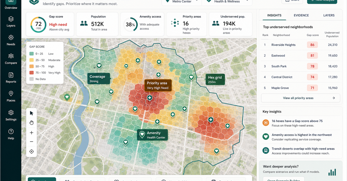
Working web maps
Clickable map workflows for site screening, route review, field operations, and reporting.
A short path for teams that already know they need a map, imagery review, report workflow, or geospatial automation and want to start with the closest working example.
Government, business, infrastructure since 2018
Clickable map workflows for site screening, route review, field operations, and reporting.
NAIPAI, feature extraction, pool extraction, solar classification, and infrastructure extraction proof.
Reports, ranked tables, QA notes, export packets, and scoped implementation paths.
Campaign-only booking bridge, not an organic SEO page unless later re-scoped.
Show three proof thumbnails before asking for the booking action.
Explain the offer without building another broad services page.
Route immediately to the booking flow with source attribution.
Bring the closest real workflow. We map what you send, what your team reviews, what evidence stays visible, and what you receive at handoff.
Campaign click, known interest, or direct referral.
Visitor sees a tiny proof set and one clear booking action.
Proof thumbnails point to real Geospatial Solutions demos.
Booking on geospatialsolutions.co.
This is not an organic SEO page unless intentionally rebuilt.
Do not add sitemap or article expansion while it remains a redirect bridge.
Live Geospatial Solutions proof demos.
Campaign attribution and booking path.
Booking URL.
No vague discovery phase. You bring four or five things, we return a specific plan you can evaluate.
No open-ended retainers. No "discovery phases" that bill for months without producing anything you can evaluate.
You send a data sample and a target outcome. We return a written scope, fixed price, and pilot plan within 48 hours.
A clickable web map or analysis run on a slice of your data — fixed fee, evaluable in under 2 weeks.
Full build with documentation, runbooks, and source code transfer. Deployed on your infrastructure or ours.
Recorded walkthroughs, training session with your team, and 30-day hardening period where we stay on call.
These open the real, interactive demos on our main site — not screenshots, not videos. Click around before you decide to talk to us.
No. This page is intentionally short. It points to proof examples and then routes qualified visitors to booking.
Start with the web-map catalog and pick the closest demo: imagery review, field workflow, routing, reporting, foot traffic, pool extraction, solar classification, or infrastructure extraction.
The first call focuses on your data, desired output, source constraints, and the smallest useful proof build.
Start with a working map example, then talk through the data, decisions, and deliverable your team needs. We w…
Choose the closest workflow, send the rough context, and we will turn it into a scoped path for a map, report,…
Custom web maps, imagery review, field systems, automation, annotation, and decision reports for teams that ne…
Dispatch optimization, container tracking, and demand prediction built for roll-off dumpster companies — runni…
Free, 30 minutes, no slide deck. We will look at your data live and tell you what is buildable, what is not, and what a realistic timeline looks like.
Book a geospatial scoping call